Birthday special
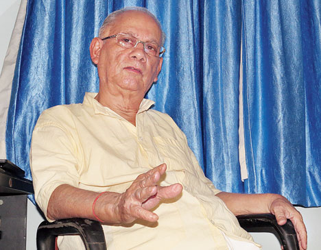
It has been 22 years since he retired as administrator of Salt Lake Reclamation and Development Project, having handed over the reins of the township to the newly formed Bidhannagar Municipality the year before, but Pran Kishore Chatterjee still has data related to the formative years of Salt Lake at his fingertips.
Seated in his AD Block home, the 80-year-old reminisces about the time when chief minister Bidhan Chandra Roy visualised founding the Calcutta Eastern Garden Suburb. “The city was bound on the west by the river, the southern fringes were becoming refugee colonies which would have been tough to dislodge. So the east was the only direction to expand. He had once travelled by launch till the house of Hem Chandra Naskar (former Calcutta mayor) near Mahisbathan and I have heard it was during that voyage that the idea came to him.”
The idea was to reclaim about 6 sq miles of the marshland by dredging the bed of river Hooghly and pumping in the slush. An estimated 124 crore cubic feet of earth would be needed to raise the area to +12. This was a unit followed by the public works department to determine how much higher the land level of a place would be compared to the Hooghly water level. “Salt Lake was originally a low-lying saucer-shaped area, where the waste of Dum Dum Park and Bangur would be drained. That also helped pisciculture practised here. The area was now to be raised to a level high enough to ensure that it would never suffer inundation. That is why Sector I and most parts of Sector II have no need for drainage pumping. Water naturally gravitates to Kestopur Canal. A drainage pumping station was built much later for Sector III opposite Nicco Park when the area was found to be too far from Kestopur Canal. The Eastern Drainage Canal was excavated for the purpose.”
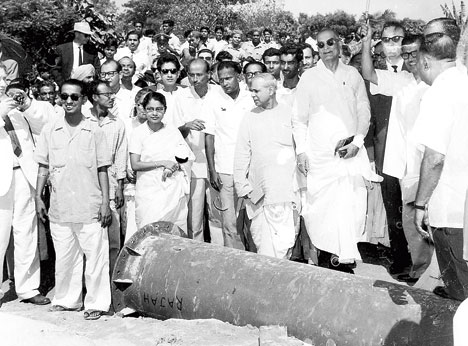
The dredging started on April 16, 1962 and 11 floating units (two dredgers, two tug pusher boats, two bergs and two survey launches and three boosting stations) were deployed.
A survey had earlier been done on the Hooghly to check where the riverbed level was highest. A shoal at Ghushuri, near Chitpore Lockgate, was deemed the closest. That is where the dredging started. Using a booster pump, the slush was sent to Ultadanga, near Golaghata. The soil would be dumped at the site while the water would be drained into Kestopur Canal.
By 1967, about 90-95 per cent dredging was done. By then, the young engineer had participated in the government’s Re 1 lottery for distribution of plots in 1965 and got three cottahs at Rs 2,750 per cottah. “We used to stay in Jodhpur Park then. Since there was no transport, the Salt Lake Project ran a bus from Ultadanga crossing just to show prospective buyers how the area was developing. Still there was little interest as people thought houses built on a bed of sand would sink.”
One day, he brought his wife and father-in-law to show the plot. “A few houses dotted the expanse amid dense overgrowths of bulrushes. There was not a single tree in sight. The wind blew sand into the eyes and nostrils. I still remember my father-in-law’s sombre face when he set foot here.”
The Chatterjees did move into their newly built house in 1979 and stayed for two-three years before he was transferred. They settled permanently in 1988. He took over as administrator the year after. The Bidhannagar Notified Area Authority came into being in 1990.
“Initially when we were planting trees, we avoided fruit-bearing trees so that there would be no disputes over the fruits. But that kept the birds away. So we changed our decision and planted mango, wood-apple, jamun later.” Another lesson learnt along the way was keeping space for cooperatives and not just individual plots. “That is why you see all the cooperative complexes in Sector III which was the last to come up.”
Three types of roads were planned — arterial, spinal and local i.e. inside blocks varying in width from 48.46m to 9.14m. Interestingly, First Avenue is not the widest because it was never meant to be the primary gateway it has become.
“Second Avenue was supposed to be the arterial road. But when dredging started the familes that stayed in the area relocated to the highland which later became Duttabad slum. We never bothered about them then as we could carry out our work. But later when their presence blocked the exit from Second Avenue to the Bypass, an alternative exit had to be found in CA Block.”
He takes a lot of pride in pointing out that 23 per cent space was kept for roads. “At that time, the figure was barely 7 per cent for Calcutta.”
And though New Town was born long after his retirement, he likes to believe he made a contribution there too. “Gautam Deb (then the chairman of Hidco and the housing minister) had sought my advice. I told him not to repeat the mistake made with Salt Lake where no one from outside could make out how the township was developing. I asked him to first curve out a road to the airport through the project area so that people could see the development being undertaken,” he smiles.
DID YOU KNOW?
Originally 15sq km of marshy land was supposed to be reclaimed. But there was hue and cry about drainage getting clogged so Nalban and Chinta Singh Bheri were left out and the remaining 12.35sq km was reclaimed.
source: http://www.telegraphindia.com / The Telegraph,Calcutta,India / Home> Calcutta / by Sudeshna Banerjee / April 13th, 2018
Why the name salt lake?. Has it anything to do with bay of Bengal water connexion? Hearsay has it that way.
Why the name salt lake?. Has it anything to do with bay of Bengal water connexion? Hearsay has it that way. Is it a spam site?